KSZP Airport Information
Santa Paula Airport welcomes you to come and enjoy some of our great, friendly hospitality! This page will give you important information about our airport stats.
Need a place to stay or a vehicle to get you there? Here's a couple of local choices!
Air BNB - Private cozy bungalow or Hillside treasure guesthouse. And get there in a rental from Turo.
Caution
In case you haven't read them yet, please become fully conversant with KSZP's non-standard patterns, and the aerobatic area rules, which is located just up the valley to the east.
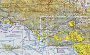
| Airport Use: Open to the public CTAF: 122.9 Pattern Altitude: 843 ft. MSL Sectional Chart: Los Angeles Variation: 14E (1985) ARTCC: Los Angeles Center FSS: Hawthorne Flight Service Station ~ 1-800-WX-BRIEF NOTAMs Facility: HHR (NOTAM-D Service) | Departure Frequencies: W - 123.75 (Pt Mugu) | E - 120.40 (SoCal) | SE - 134.20 (SoCal) Attendance: 0800-1700 LCL Activation Date: April 1930 Instrument Approaches: None (see Nav Aids tab) WX ASOS at CMA (8 nm S): PHONE 805-384-9294 WX ASOS at OXR (11 nm SW): PHONE 805-382-0569 Fuel Available: 100LL - 24 hr self-serve with major credit card |
Runway 22 is also the no wind runway
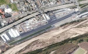
Dimension: 2713 x 60 ft / 826.9 x 18.3 m
Elevation: 248ft
Traffic Pattern: Left
Displaced threshold: 225ft
Runway End Identifier: No
Centerline Lights: No
Touchdown Lights: No
Obstructions: 16 ft trees, 200.0 ft from runway, 125 ft right of centerline
RWY 22 APCH RATIO 22:1 TO DSPLCD THLD TREES & WIRES; ; APCH RATIO TO DSPLCD THLD 14:1 OVER +16 FT BLDG 220 FT FM DSPLCD THLD 135 FT RT.
Dimension: 2713 x 60 ft / 826.9 x 18.3 m
Elevation: 240ft
Traffic Pattern: Right
Displaced threshold: 197ft
Runway End Identifier: No
Centerline Lights: No
Touchdown Lights: No
Obstructions: 16 ft bldg, 350.0 ft from runway, 95 ft left of centerline, 9:1 slope to clear
RWY 04 APCH RATIO 33:1 FROM DSPLCD THLD DUE TO +15 FT BRUSH 500 FT FROM DSPLCD THLD 20:1 OVR 15 FT TREES 150 FT RT AMD 300 FT FM DSPLCD THLD.
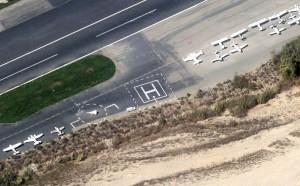
Dimension: 60 x 60ft / 18.3 x 18.3m
Traffic pattern: Left
Arrival / Departure: Approach and depart from the south. Avoid the flow of fixed wing traffic.
Warnings: Do not overfly the runway. Do not cross the Runway for fuel! Call fuel truck at 805-415-0223
There are no published instrument procedures at KSZP. Some nearby airports with instrument procedures:
KCMA - Camarillo Airport (8 nm S)
KOXR - Oxnard Airport (11 nm SW)
KNTD - Point Mugu Naval Air Station (Naval Base Ventura County) (14 nm S)
KVNY - Van Nuys Airport (30 nm E)
KWHP - Whiteman Airport (33 nm E)
| ID | TYPE | NAME | CH | FREQ | VAR | DIST |
| PAI | NDB | Pacoima | 370.00 | 15E | 32.6 nm | |
| GWF | NDB | Gen William J Fox | 282.00 | 15E | 48.0 nm | |
| CPM | NDB | Compton | 378.00 | 15E | 49.0 nm | |
| NTD | TACAN | Point Mugu | 043X | 15E | 13.8 nm | |
| CMA | VOR/DME | Camarillo | 105X | 115.80 | 15E | 8.2 nm |
| VTU | VOR/DME | Ventura | 019X | 108.20 | 15E | 14.0 nm |
| VNY | VOR/DME | Van Nuys | 078X | 113.10 | 15E | 29.3 nm |
| SMO | VOR/DME | Santa Monica | 045X | 110.80 | 15E | 36.3 nm |
| FIM | VORTAC | Fillmore | 072X | 112.50 | 15E | 9.0 nm |
| GMN | VORTAC | Gorman | 108X | 116.10 | 16E | 29.2 nm |
| LHS | VORTAC | Lake Hughes | 021X | 108.40 | 15E | 31.4 nm |
| RZS | VORTAC | San Marcus | 096X | 114.90 | 14E | 36.5 nm |
| LAX | VORTAC | Los Angeles | 083X | 113.60 | 15E | 40.0 nm |
- ULTRALIGHTS; BANNER TOWING; GLIDERS; RC MODELS OPER IN THE VICINITY.
- DAILY AEROBATIC ACTIVITY 3-18 MILES EAST UP TO 5,255 FT AGL, MONITOR ON 122.775.
- BE ALERT TO WIRES CROSSING OVER RIVER BED ADJACENT TO RY 04/22. LOCATIONS: 1.5 MILES & 3.5 MILES SW APCH END RY 04. ALSO, 1,500 FT AND 2.5 MILES NE APCH END RY 22.
- HEL MUST USE DSGND HELI LCTD MID-FIELD ON THE SOUTH SIDE. ALL APCHS/DEPS ARE FROM THE SOUTH
- TSNT HEL RSRTD TO THE HELI. HOVER TAXI NOT AUTH.
- 2200 FT MT 1 NM S OF ARPT; FOR NOISE ABATEMENT MNTN 1500 FT UPWIND OVR CITY.
- NO OHD APCHS; NO 45 DEG ENTRIES; NO CROSSWIND ENTRIES OVR RWY.
- STAS NOT RCMDD.
- ENTER PAT FM EXTDD DOWNWIND LEG OR ENTER FM A CROSSWIND LEG AT LEAST 1 MI BYD THE DEP END OF ACTIVE RWY.
- NIGHT OPNS PROHIBITED.
- +4 FT SIGN IN PRMARY SFC AT NE END OF ARPT.