Santa Paula Airport

(805) 933-1155

  • FLYING INTO KSZP
    • KSZP Airport Information
    • Non-Standard Traffic Pattern
    • Flying in the Aerobatic Area
    • Hangar & Tie Down Rental
  • HISTORY
    • Airport
    • Airport Daily Weather
    • Airport Yearly Weather
    • Airport Weather Charts
  • GALLERY
  • KSZP BUSINESSES
  • CONTACT/MAP
WIND & PRESSURE
Bearing: 57°
Speed: 2.5 kts
Pressure: 30.04 in
TEMPERATURE, HUMIDITY & DEWPOINT
Temperature: 54.7℉
Humidity: 92
Dewpoint: 52.3℉
PRECIPITATION
Precipitation Last Hour: 0.00 in
Precipitation Today: 0.00 in

Santa Paula Runway
JS Bin
3
KTS
▼
Bearing 57°
Gusts 4 KTS

Current Gas Price

$4.65

AIRPORT INFORMATION
MORE WEATHER DATA
  1. Contact & Directions
  2. Contact Form

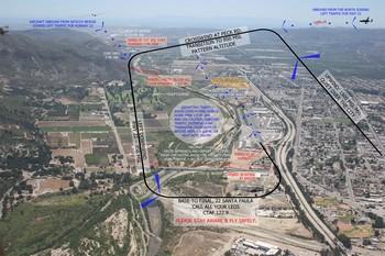
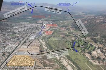
Address: 800 E. Santa Maria St, 28 Wright Taxiway, Santa Paula, CA 93060

Phone: (805) 933-1155

Office Hours:

See the hangar map >>


Directions

From Ventura, CA

  • Get on CA-126 E from Telegraph Rd and S Victoria Ave
    5 min (1.6 mi)
  • Follow CA-126 E to S Palm Ave in Santa Paula. Take exit 11 from CA-126 E
    9 min (9.9 mi)
  • Drive to Frontage Rd/E Santa Maria St
    1 min (0.5 mi)

From Fillmore, CA

  • Head south on Ventura St toward Old Telegraph Rd
    5 min (o.2 mi)
  • Turn right onto CA-126 W/W Telegraph Rd/W Ventura St
    Continue to follow CA-126 W
    (8.8 mi)
  • Take exit 12 for CA-150/10th St toward Santa Paula
    (0.2 mi)
  • Turn left onto CA-150 E/S 10th St
    Continue to follow S 10th St
    (308 ft)
  • Turn right onto Frontage Rd/E Santa Maria St
    (0.2 mi)

This site is protected by reCAPTCHA and the Google Privacy Policy and Terms of Service apply.

History of Santa Paula Airport

After the St. Francis Dam disaster in 1928, local ranchers Ralph Dickenson and Dan Emmett decided some of the devastated area adjacent to the river would make a good location for an airport. They both had airstrips on their ranches and recognized that a single airport would greatly benefit everyone in the Santa Paula area. Nineteen local ranchers and businessmen pooled their resources and began building with their own hands the Santa Paula Airport. Aviation heroes of the day came to the airport dedication ceremonies in August of 1930.

In February 2005, the rain-swollen Santa Clara River ate into the airport, destroying tiedowns, ramp and about 600' of the west end of the runway. Repairs commenced after the water receded, and the airport was reopened to the public 2 years later in February 2007.

The airport today

Today Santa Paula Airport is a non-towered facility handling approximately 97,000 arrivals and/or departures a year, and is home to nearly 300 aircraft. It is also home to a small number of helicopters, gliders & ultrlights.

The airport today is smaller than local airports, primarily serving the local community and providing hangar space for pilots of nearby communities. Much of the original 1930’s-era facilities still exist and are used today, giving the airport a very authentic representation of the Golden Age of Aviation.

Because of this yesteryear feel, KSZP is home to many vintage aircraft and hangar space is well sought after. The airport also boats the Aviation Museum of Santa Paula, a must-see for all aviation buffs.

Name dropping

Santa Paula Airport has seen, or been home to a number of interesting and colorful characters over the years. Best known, of course, is actor Steve McQueen, who not only had a number of classic aircraft hangered at the airport, but lived out his final years in the city of Santa Paula. Among his "gaggle" was the award-winning 1931 Pitcairn PA-8 biplane, an aircraft flown in the US Mail Service by legendary WW1 ace, Eddie Richenbacker.

The actors didn't stop with Steve McQueen. During the opening of the original airport in August 1930, a crowd of 6,000 odd spectators were treated to glider flights, parachute jumps, air races, the local high school band, and a stunt show by movie stunt pilot, and Californian, Garland Lincoln, and local aviatrix, and stunt pilot, Edith Bond.


east small

Santa Paula Special Traffic Patterns

Santa Paula Airport has a non-standard traffic pattern. If you are new to the area please take a moment to review our procedures. Select a runway below for more information. Fly safe!

  1. West/No Wind - Rwy 22
  2. East Wind - Rwy 04

VIEW IMAGE IN A POPUP
GET FULL-SIZE PDF VERSION
AEROBATIC AREA INFORMATION

Runway 22 : West Wind / Calm Wind

Use frequency 122.9 – Be vigilant for aircraft without radios.

Please, no 45 degree entries over the ridge to downwind, or overhead crosswind entries from upwind. Please extend your upwind to Peck Rd., just to the west of the trailer park before turning crosswind.

Pattern altitude is 850′ MSL


ARRIVALS

Aircraft arriving from the south, southwest, west and northwest:

  1. Join a long left downwind for runway 22.
  2. Report Saticoy bridge (6.25mi SW) and/or the junkyard (3mi SW).
  3. Descend to pattern altitude (850′ msl)
  4. Report left downwind over the golf course, left base and final.

Aircraft arriving from the Southeast, east, northeast and north:

  1. Report upwind over the city at 1500′ msl
  2. Report left crosswind at Peck Rd (1.5mi west)
  3. Descend to pattern altitude (850′ msl)
  4. Report left downwind over the golf course, left base and final.

DEPARTURES

Westbound departures, please avoid direct overflight of noise sensitive mobile home park. Be vigilant for arrival traffic on long left downwind for Runway 22. Eastbound departures, be alert for intensive aerobatic training beginning 3mi east of SZP. Pilots are requested to announce their position and monitor on 122.775.

VIEW IMAGE IN A POPUP
GET FULL-SIZE PDF VERSION
AEROBATIC AREA INFORMATION

Runway 04 : East Wind

Use frequency 122.9 – Be vigilant for aircraft without radios.

Please, no 45 degree entries over the ridge to downwind, or overhead crosswind entries from upwind. Please extend your upwind to Santa Paula Creek before turning crosswind.

Pattern altitude is 850′ MSL


ARRIVALS

Aircraft arriving from the southwest, west and northwest

  1. Fly upwind over the city at 1500′ msl
  2. Turn crosswind at or beyond Santa Paula Creek
  3. Descend to pattern altitude (850′ msl)
  4. Report right downwind, right base and final

Aircraft arriving from the South, Southeast, east, northeast and north:

  1. Join an extended right downwind for 04
  2. Report Crossing power lines (3.5mi east)
  3. Descend to pattern altitude (850′ msl)
  4. Report right downwind, right base and final

DEPARTURES

Eastbound departures, please be vigilant for arrival traffic on long right downwind for Runway 04. Be alert for intensive aerobatic training beginning 3mi east of SZP. Pilots are requested to announce their position and monitor on 122.775.

Page 5 of 6

  • 1
  • 2
  • 3
  • 4
  • 5
  • 6

Home | Hangar & Tie Down Rental | Contact | Privacy Policy

Copyright © 1930 - . Santa Paula Airport. All rights reserved. | KSZP STAFF

Aviation Museum of Santa Paula | Phoenix Website Design by CitrusKiwi

Find on FB small

Subscribe to our Newsletter